SIMPLE MODEL FOR TSUNAMI HAZARDS ESTIMATION – CASE STUDY : BANTUL REGENCY, YOGYAKARTA PROVINCE – A tsunami (pronounced sue-nahm-ee) is a series of huge waves that can cause great devastation and loss of life when they strike a coast.Tsunamis are caused by an underwater earthquake, a volcanic eruption, an sub-marine rockslide, or, more rarely, by an asteroid or meteoroid crashing into in the water from space. Most tsunamis are caused by underwater earthquakes, but not all underwater earthquakes cause tsunamis – an earthquake has to be over about magnitude 6.75 on the Richter scale for it to cause a tsunami. About 90 percent of all tsunamis occur in the Pacific Ocean
The word tsunami comes from the Japanese word meaning “harbor wave.” Tsunamis are sometimes incorrectly called “tidal waves” — tsunamis are not caused by the tides (tides are caused by the gravitational force of the moon on the sea). Regular waves are caused by the wind. A tsunami starts when a huge volume of water is quickly shifted. This rapid movement can happen as the result of an underwater earthquake (when the sea floor quickly moves up or down), a rock slide, a volcanic eruption, or another high-energy event. After the huge volume of water has moved, the resulting wave is very long (the distance from crest to crest can be hundred of miles long) but not very tall (roughly 3 feet tall). The wave propagates (spreads) across the sea in all directions; it can travel great distances from the source at tremendous speeds.
A tsunami can travel at well over 970 kph (600 mph) in the open ocean – as fast as a jet flies. It can take only a few hours for a tsunami to travel across an entire ocean. A regular wave (generated by the wind) travels at up to about 90 km/hr. As a tsunami wave approaches the coast (where the sea becomes shallow), the trough (bottom) of a wave hits the beach floor, causing the wave to slow down, to increase in height (the amplitude is magnified many times) and to decrease in wavelength (the distance from crest to crest).At landfall, a tsunami wave can be hundreds of meters tall. Steeper shorelines produce higher tsunami waves. In addition to large tsunami waves that crash onto shore, the waves push a large amount of water onto the shore above the regular sea level (this is called runup). The runup can cause tremendous damage inland and is much more common than huge, thundering tsunami waves.
Required Data and Methods
- Required Data
Area boundaries, geology information, slope information, and landuse information.
- Methods
Method used in this research is to calculating coverage area of tsunami using ArcGIS software with overlay method. This method is done by making a score for each map (geology map, landuse map, and slope map). Then all score sum into the final score. final score is used to perform hazard level classifier.
Score For Landuse
| No | Landuse | Score |
| 1 | Settlement, Rice field, Swamp | 5 |
| 2 | Farm | 4 |
| 3 | Field | 3 |
| 4 | Sand, Bush, Grass | 2 |
| 5 | Forest | 1 |
Score For Geology
| No | Material | Score |
| 1 | Aluvium | 5 |
| 2 | Young Quarter | 4 |
| 3 | Old Quarter | 3 |
| 4 | Sediment | 2 |
| 5 | Limestone | 1 |
Score For Slope
| No | Slope | Score |
| 1 | 0 % – 8 % | 5 |
| 2 | 8 % – 15 % | 4 |
| 3 | 15 % – 25 % | 3 |
| 4 | 25 % – 40 % | 2 |
| 5 | > 40 % | 1 |
Final Score
| No | Final Score | Vulnerabilty |
| 1 | 0 – 3 | No Prone |
| 2 | 4 – 6 | Less Prone |
| 3 | 7 – 9 | Medium Prone |
| 4 | 9 – 12 | Prone |
| 5 | 12 – 15 | High Prone |
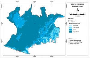
Result
Components to consider in the tsunami-prone map compilation is landuse, soil material, and slope aspect. From The Map, the highest level of tsunami vulnerability located to the south and north of Bantul, this is because the area is a plateau region. For medium level of vulnerability is in the western region of Bantul, which area is rather high. Whereas low level of vulnerability located to the east of Bantul is located in hilly areas.