This article is summarized and concluded from articles as follow:
(1) Making GIS Work in Forest Management by Manij Upadhyay, unpublished work.
(2) A Hierarchical Approach to Spatial Forest Planning by Ugo Feunekes and Andrew Cogswell, USDA Forest Service, Proceeding
(3) HCVF/A Identify Within Ecoregion; Integrating Conservation Planning into Regional Spatial Planning by Barano Siswa Sulistyawan, WWF Indonesia,
(4) Assessing participatory GIS for community-based natural resources management: claiming community forests in Cameroon by Michael K. McCall and Peter A. Minang, The Geography Journal Volume 171 No.(4) pages 283-306, 2010
Previous Section – Integrating Conservation Planning Into Regional Spatial Planning (Case Study of WWF Indonesia)
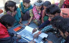
Participatory GIS (PGIS) for Community Based Natural Resources Management (Case Study in Tinto, Cameroon)
Integrating GIS into Forest Resources Spatial Management and Planning (5) — There is an apparent lack of socio-economic data that could be used for GIS in forest management. Hence, there is a recent trend to encourage participation in forest management strategies. There is an often implicit assumption that PGIS use is effective, in that it meets content needs, satisfies underlying local stakeholder interests and therefore is a tool for better governance. It was found that PGIS/participatory mapping processes contributed – positively, though not comprehensively – to good governance, by improving dialogue, redistributing resource access and control rights – though not always equitably – legitimizing and using local knowledge, exposing local stakeholders to geospatial analysis, and creating some actor empowerment through training. PGIS promoted empowerment by supporting community members’ participation in decision-making and actions, and by enabling land use planning decisions beyond community forestry itself. (Minang and McCall, 2005).
PGIS and participatory mapping have two decades of applications in participatory spatial planning, whether manifested as rural-located ‘community-based natural resources’ or as ‘participatory neighborhood planning’ in urban settings:
- ‘Claiming land’ – legal recognition of customary land and resource rights, or demarcating neighborhood boundaries.
- Management of customary land and resources, usually under ‘traditional’ management systems.
- Managing competition and ameliorating conflicts.
- Mapping social and environmental inequalities.
- ‘Building community’, strengthening community awareness and cultural identity.
Participation is a key element among the criteria of ‘good governance’ for effective participatory spatial planning. Participation in PGIS can be characterized both into types and intensities, from lowest to highest.
- Manipulative and passive participation involving information flows between local people and ‘outsiders’, regarding primarily technical information, such as resource assessment, e.g. participatory mapping in many rapid rural appraisal exercises.
- Consultation or functional participation – outsiders refer selected, focused issues to local stakeholders, and interpret their responses into ‘scientific’ frameworks, such as maps of ‘needs’.
- Interactive involvement in decision-making by all actors in most stages – ‘participation seen as a right, not just as the means to achieve outsiders’ project goals’.
- Initiating actions – independent initiatives from, and ‘owned’ by, local people; or self-mobilization. This is a strong indicator of empowerment.
Principles and practices in participatory spatial planning and good governance contain several aspects as follows:
- Legitimacy and participation
- Empowerment
- Respect for local peoples and their local and indigenous knowledge
- Respect for indigenous spatial knowledge and people’s cognition of land
- Ownership of spatial knowledge and process
- Equity within the ‘governed’, and between ‘governing’ and ‘governed’
- Effectiveness and competence: dealing with imperfect data and spatial (im)precision
- Effectiveness: technical manageability of PGIS at the local level by local people
Remarks:
You can download the full paper in PDF at the end of the lecture series.
*Geo-information for Spatial Planning and Risk Management — Batch 6 — Faculty of Geography, Gadjah Mada University*
*Intended to fulfil Spatial Planning lecture task*