This article is summarized and concluded from articles as follow:
(1) Making GIS Work in Forest Management by Manij Upadhyay, unpublished work.
(2) A Hierarchical Approach to Spatial Forest Planning by Ugo Feunekes and Andrew Cogswell, USDA Forest Service, Proceeding
(3) HCVF/A Identify Within Ecoregion; Integrating Conservation Planning into Regional Spatial Planning by Barano Siswa Sulistyawan, WWF Indonesia,
(4) Assessing participatory GIS for community-based natural resources management: claiming community forests in Cameroon by Michael K. McCall and Peter A. Minang, The Geography Journal Volume 171 No.(4) pages 283-306, 2010
Previous Section – A Hierarchical Approach to Spatial Forest Planning to Create Harvest Blocks (Case study of Remsoft)
Integrating Conservation Planning Into Regional Spatial Planning (Case Study of WWF Indonesia)
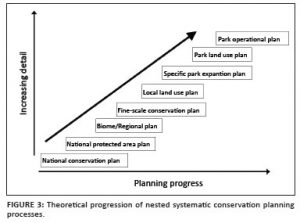
Integrating GIS into Forest Resources Spatial Management and Planning (4) — The concept on High Conservation Value Forest (HCVF) has introduced by Forest Stewardship Council (FSC) in 1999. Now, this approach is adopting in several country for strengthen conservation efforts and reducing natural forest conversion especially in outside protected area. The toolkit has also applied in oil palm concession, logging concession and in landscape level. The latest progress is using HCVF assessment inside ecoregion unit. Basic of ecoregion analysis is based on spatial approach. The ecoregion boundary has become analysis unit for identified the biodiversity, ecological and social culture values.
Priors to spatial planning process, there are steps to be done:
- Define unit analysis
- Regional spatial planning base on municipality, regency or province administration boundary.
- The conservation planning base on ecological or ecosystem region such as wild life home range, watershed area, geographic landscape, ecoregion.
- Define conservation target inside ecoregion area.
- Six elements of HCV as a target for define and delineate into spatial format as well as the analysis unit.
- For design six elements of HCV could use primary or secondary data.
- Each HCV’s delineate process can be used some spatial method.
- Data spatial collecting method
- HCV 1: Use field survey data such as coordinate of GPS or compilation from researcher data result. To define and delineate process could be done by experts. Not all species habitat will delineate but important species such some endemic area or threaten species habitat. To fine big mammal habitat such elephant or tiger could use radio tracking data monitoring or field survey with GPS.
- HCV 2: Extrapolation from remote sensing data such as LANDSAT, SPOT, MODIS, RADAR to get forest cover or others important landscape.
- HCV 3: The threaten ecosystem or forest could define from synthesis of land system, land form and vegetation map.
- HCV 4: Use hydrology data, elevation, peat land, land form to important fine ecological function and services.
- HCV 5 & 6: Use participatory mapping approach. The method assumes local knowledge inside of community leader mind (mental map). So, technically just provide or facilitate transform process from mental map into spatial map.
- Define planning unit
During analysis with GIS application we will define shape and size of planning unit. Shape of planning unit: Watershed unit or sub catchments unit Sub district boundary, district, and municipality. Computer unit such hexagon or square
- Cost Analysis
The conservation assessment is usually using difference cost values such as human population increase, infrastructure development, threat etc. Define cost analysis is very important to ignore unimportant area from conservation target analysis.
- Set Conservation Target
It is very difficult to set up target area for conservation. Usually expert advice is required for acceptable area delineation. During this process multi stakeholder involve is very important. It is very useful facilitate workshop with among stakeholders such represent from community leader, government, civil society organization, private sector to define where area for conservation and how much they want to conserve.
The ecoregional and HCVF approach will improve the conservation planning in landscape and ecoregion level. Furthermore, it is very useful to enrich the current model of spatial planning. The ecoregion boundary will give good understanding of ecosystem unit inside the region. The systematic conservation planning based on ecoregion analysis approach can be combined with other knowledge from experts and communities. Flexibility of process and combining information from multi stakeholder such as expert, community, government, and private, it will contribute to make easier endorsement and advocacy process into decision maker.
Remarks:
You can download the full paper in PDF at the end of the lecture series.
*Geo-information for Spatial Planning and Risk Management — Batch 6 — Faculty of Geography, Gadjah Mada University*
*Intended to fulfil Spatial Planning lecture task*