Integrating GIS into Forest Resources Spatial Management and Planning (2) – Forest Resources Spatial Management and GIS

Integrating GIS into Forest Resources Spatial Management and Planning (2) – Forest Resources Spatial Management and GIS

This article is summarized and concluded from articles as follow: (1) Making GIS Work in Forest Management by Manij Upadhyay, unpublished work. (2) A Hierarchical Approach to Spatial Forest Planning by Ugo Feunekes and Andrew Cogswell, USDA Forest Service, Proceeding (3) HCVF/A Identify Within Ecoregion; Integrating Conservation Planning into Regional Spatial Planning by Barano Siswa Sulistyawan, WWF Indonesia, (4) Assessing participatory GIS for community-based natural resources management: claiming community forests in Cameroon by Michael K. McCall and Peter A. Minang, The Geography Journal Volume 171 No.(4) pages 283-306, 2010 Previous Section Integrating GIS into Forest Resources Spatial Management and Planning (1) Forest Resources Spatial Management and GIS 
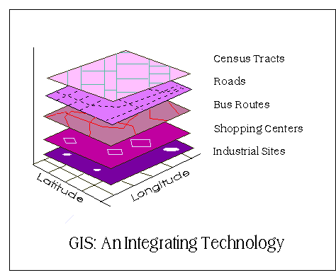
Integrating GIS into Forest Resources Spatial Management and Planning (2) -- Geographical Information Systems (GIS) is an information technology that has been used in public policy-making for environment and forest planning and decision-making over past two decades (Pradhan, 2008 and Bassole et al., 2001). GIS integrates hardware, software, and data for capturing managing, analyzing, and displaying all forms of geographically referenced information (ESRI, 2008). This makes GIS an important tool in...
Read More
Integrating GIS into Forest Resources Spatial Management and Planning (1) – Introduction

Integrating GIS into Forest Resources Spatial Management and Planning (1) – Introduction

This article is summarized and concluded from articles as follow: (1) Making GIS Work in Forest Management by Manij Upadhyay, unpublished work. (2) A Hierarchical Approach to Spatial Forest Planning by Ugo Feunekes and Andrew Cogswell, USDA Forest Service, Proceeding (3) HCVF/A Identify Within Ecoregion; Integrating Conservation Planning into Regional Spatial Planning by Barano Siswa Sulistyawan, WWF Indonesia, (4) Assessing participatory GIS for community-based natural resources management: claiming community forests in Cameroon by Michael K. McCall and Peter A. Minang, The Geography Journal Volume 171 No.(4) pages 283-306, 2010   Introduction Integrating GIS into Forest Resources Spatial Management and Planning (1) - As Indonesia becomes the third highest biodiversity country, it is important for Indonesian to conserve its forest resources. Since, without any simultaneous conservation strategies and sustainable use of forest resources, all advantageous for nation development will be vanished no more than a few years. Concerns over the impacts of forest operations on the forest landscape have compelled a number of agencies to take initiatives to address these issues (Feunekes and Cogswell, 1993)....
Read More

THIESSEN POLYGON AND ISOHYET CONTOUR METHODS FOR MEASURE AND COMPARE THE PRECIPITATION MEAN

THIESSEN POLYGON AND ISOHYET CONTOUR METHODS FOR MEASURE AND COMPARE THE PRECIPITATION MEAN A brief practical report   Below is the example of the precipitation mean measurement using thiessen polygon, and isohyet contour methods. Both methods is commonly used in climatology.  The result of thiessen polygon and isohyet contour methods shown in figures below : Tabel 1. Measurement of precipitation depth using Thiessen Polygon Station 24-hours Total Area Weighted ppt (mm) unit (%) (mm) A 78 0.05 0.3 24.04438964 B 115 1.7 10.5 1205.302096 C 140 3.8 23.4 3279.901356 D 165 2.1 12.9 2136.251541 E 150 0.95 5.9 878.5450062 F 90 3.4 21.0 1886.559803 G 175 1.8 11.1 1942.046856 H 155 2.42 14.9 2312.577065 Total 1068 16.22   13665.22811 ∑ Pn The average of preciputation depth = ∑ area                                                          = 13665.23 / 16.22                                                                      = 842.4925 mm   Tabel 2. Measurement of precipitation depth using Isohyet Contour Station Group Total Area Weighted ppt Median unit (%) (mm) 80 - 90 85 0.02 0.092208391 7.837713232 90 - 100 95 0.27 1.244813278 118.2572614 100 - 110 105 2.1 9.681881051 1016.59751 110 - 120 115 2.5 11.52604887 1325.49562 120 - 130 125 3.5 16.13646842 2017.058552 130 - 140 135 5.2 23.97418165 3236.514523 140 - 150 145 3.7 17.05855233 2473.490088 150 - 160 155 1.9 8.759797142 1357.768557 160 - 170 165 0.7 3.227293684 532.5034578 170 - 180 175 1.8 8.298755187 1452.282158 Total 1300 21.69   13537.80544 ∑ Pn The average of precipitation depth = ∑ area                                                          = 13537.8 / 21.69                                                                      = 624.15 mm   CONCLUSION The result showed the difference between both measurement. This may happen when we use a bigger grid size. The accuracy decrease since the grid cannot cover the area border precisely . Thiessen Polygon Method is simpler than isohyets contour. Isohyet method is more complex and may...
Read More
Science, Philosophy, and Physical Geography by Robert Inkpen (Chapter 2. The Nature of Reality)

Science, Philosophy, and Physical Geography by Robert Inkpen (Chapter 2. The Nature of Reality)

Bab 2. Sifat Realitas Karya Terjemahan : Science, Philosophy, and Physical Geography by Robert Inkpen. Disclaimer : Buku "Science, Philosophy, dan Physical Geography" oleh Robert Inkpen diterjemahkan oleh S.T Pradopo dalam rangka tugas mata kuliah Filsafat Ilmu Pengetahuan Program S3 Ilmu Geografi. Tidak digunakan untuk kepentingan komersial. Harap selalu mencantumkan pengarang dan sumber referensi apabila ada pihak-pihak yang ingin menggunakan. Terimakasih. Ringkasan Geografi fisik mempelajari kenyataan dianggap sebagai entitas eksternal dan dapat dipelajari. Meskipun mereka tidak pernah dapat memiliki pengetahuan mutlak terhadap realitas eksternal ini mereka dapat mengatur dan menggunakan informasi untuk berdebat dan mencapai kesepakatan tentang sifat representasi mereka tentang realitas. Positivisme logis percaya kemungkinan untuk merasakan kenyataan sebagaimana galibnya dan bahwa mungkin untuk menemukan hukum yang sebenarnya mengenai entitas riil melalui informasi sensor. Penelitian diarahkan untuk membuktikan realitas sebagaimana seperti yang kita percaya itu harus menjadi. Rasionalisme kritis mengambil pandangan yang lebih kritis dari pencarian atas sebuah realitas. Para rasionalis kritis melihat pengujian dan memalsukan ide sebagai fitur penting dari penelitian ilmiah. Pengetahuan tidak...
Read More
UNDERSTANDING OUR PLANET Q/A #6 – What geologic processes might cause the forces that can hold a region out of isostatic equilibrium?

UNDERSTANDING OUR PLANET Q/A #6 – What geologic processes might cause the forces that can hold a region out of isostatic equilibrium?

UNDERSTANDING OUR PLANET Q/A #6 - What geologic processes might cause the forces that can hold a region out of isostatic equilibrium? - On a geological scale, isostasy can be observed where the Earth's strong lithosphere exerts stress on the weaker asthenosphere which, over geological time flows laterally such that the load of the lithosphere is accommodated by height adjustments. It was ascertained that disturbances of the isostatic equilibrium are the result of the active geotectonic process and that isostatic forces are passive as tectonic factor. In the geological time scale the readjustment takes place instantaneously, therefore isostatic anomalies of gravity may be considered as direct indications of the modern tectonic activity. However, some continental collisions are far more complex than this, and the region may not be in isostatic equilibrium. Certain areas (such as the Himalayas) are not in isostatic equilibrium, in the case of the Himalayas, by proposing that their elevation is being "propped-up" by the force of the...
Read More