MAHIR MENULIS, 12 CARA CEPAT MEMBUAT TULISAN MENARIK DALAM WAKTU SINGKAT

MAHIR MENULIS, 12 CARA CEPAT MEMBUAT TULISAN MENARIK DALAM WAKTU SINGKAT

Mahir Menulis, Cara Cepat Membuat Tulisan Menarik dalam Waktu Singkat — Dalam artikel ini anda akan dapat menemukan bagaimana cara cepat untuk mahir menulis. Setelah membaca tulisan ini ditambah dengan sedikit latihan, maka anda akan dengan mudah membuat sebuat tulisan hanya dalam waktu kurang dari satu jam. Silahkan cermati tulisan tentang bagaimana cara menulis secara cepat dalam kumpulan tips Mahir Menulis, Cara Cepat Membuat Tulisan dalam Waktu Singkat. Tentukan tema Tulisan yang baik adalah tulisan yang memiliki tema yang spesifik. Satu tulisan sebaiknya hanya memuat satu tema utama. Anda bisa saja memuat dua atau tiga tema dalam satu tulisan, namun tentu itu melelahkan bagi pembaca anda. Alih-alih memaksakan lebih dari satu tema utama pada tulisan anda, lebih baik membuat sub-sub tema yang satu ide dengan tulisan utama anda. Cara ini justru akan membuat tulisan anda semakin kaya tanpa harus membuat pembaca lelah harus berpindah-pindah pada beberapa tema. Tentukan hal yang paling menarik Hal yang menarik adalah kunci. Anda dapat memilih satu tema...
Read More
Integrating GIS into Forest Resources Spatial Management and Planning (2) – Forest Resources Spatial Management and GIS

Integrating GIS into Forest Resources Spatial Management and Planning (2) – Forest Resources Spatial Management and GIS

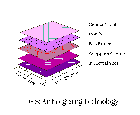
This article is summarized and concluded from articles as follow: (1) Making GIS Work in Forest Management by Manij Upadhyay, unpublished work. (2) A Hierarchical Approach to Spatial Forest Planning by Ugo Feunekes and Andrew Cogswell, USDA Forest Service, Proceeding (3) HCVF/A Identify Within Ecoregion; Integrating Conservation Planning into Regional Spatial Planning by Barano Siswa Sulistyawan, WWF Indonesia, (4) Assessing participatory GIS for community-based natural resources management: claiming community forests in Cameroon by Michael K. McCall and Peter A. Minang, The Geography Journal Volume 171 No.(4) pages 283-306, 2010 Previous Section Integrating GIS into Forest Resources Spatial Management and Planning (1) Forest Resources Spatial Management and GIS Integrating GIS into Forest Resources Spatial Management and Planning (2) -- Geographical Information Systems (GIS) is an information technology that has been used in public policy-making for environment and forest planning and decision-making over past two decades (Pradhan, 2008 and Bassole et al., 2001). GIS integrates hardware, software, and data for capturing managing, analyzing, and displaying all forms of geographically referenced information (ESRI, 2008). This makes GIS an important tool in...
Read More
Integrating GIS into Forest Resources Spatial Management and Planning (1) – Introduction

Integrating GIS into Forest Resources Spatial Management and Planning (1) – Introduction

This article is summarized and concluded from articles as follow: (1) Making GIS Work in Forest Management by Manij Upadhyay, unpublished work. (2) A Hierarchical Approach to Spatial Forest Planning by Ugo Feunekes and Andrew Cogswell, USDA Forest Service, Proceeding (3) HCVF/A Identify Within Ecoregion; Integrating Conservation Planning into Regional Spatial Planning by Barano Siswa Sulistyawan, WWF Indonesia, (4) Assessing participatory GIS for community-based natural resources management: claiming community forests in Cameroon by Michael K. McCall and Peter A. Minang, The Geography Journal Volume 171 No.(4) pages 283-306, 2010   Introduction Integrating GIS into Forest Resources Spatial Management and Planning (1) - As Indonesia becomes the third highest biodiversity country, it is important for Indonesian to conserve its forest resources. Since, without any simultaneous conservation strategies and sustainable use of forest resources, all advantageous for nation development will be vanished no more than a few years. Concerns over the impacts of forest operations on the forest landscape have compelled a number of agencies to take initiatives to address these issues (Feunekes and Cogswell, 1993)....
Read More

THIESSEN POLYGON AND ISOHYET CONTOUR METHODS FOR MEASURE AND COMPARE THE PRECIPITATION MEAN

THIESSEN POLYGON AND ISOHYET CONTOUR METHODS FOR MEASURE AND COMPARE THE PRECIPITATION MEAN A brief practical report   Below is the example of the precipitation mean measurement using thiessen polygon, and isohyet contour methods. Both methods is commonly used in climatology.  The result of thiessen polygon and isohyet contour methods shown in figures below : Tabel 1. Measurement of precipitation depth using Thiessen Polygon Station 24-hours Total Area Weighted ppt (mm) unit (%) (mm) A 78 0.05 0.3 24.04438964 B 115 1.7 10.5 1205.302096 C 140 3.8 23.4 3279.901356 D 165 2.1 12.9 2136.251541 E 150 0.95 5.9 878.5450062 F 90 3.4 21.0 1886.559803 G 175 1.8 11.1 1942.046856 H 155 2.42 14.9 2312.577065 Total 1068 16.22   13665.22811 ∑ Pn The average of preciputation depth = ∑ area                                                          = 13665.23 / 16.22                                                                      = 842.4925 mm   Tabel 2. Measurement of precipitation depth using Isohyet Contour Station Group Total Area Weighted ppt Median unit (%) (mm) 80 - 90 85 0.02 0.092208391 7.837713232 90 - 100 95 0.27 1.244813278 118.2572614 100 - 110 105 2.1 9.681881051 1016.59751 110 - 120 115 2.5 11.52604887 1325.49562 120 - 130 125 3.5 16.13646842 2017.058552 130 - 140 135 5.2 23.97418165 3236.514523 140 - 150 145 3.7 17.05855233 2473.490088 150 - 160 155 1.9 8.759797142 1357.768557 160 - 170 165 0.7 3.227293684 532.5034578 170 - 180 175 1.8 8.298755187 1452.282158 Total 1300 21.69   13537.80544 ∑ Pn The average of precipitation depth = ∑ area                                                          = 13537.8 / 21.69                                                                      = 624.15 mm   CONCLUSION The result showed the difference between both measurement. This may happen when we use a bigger grid size. The accuracy decrease since the grid cannot cover the area border precisely . Thiessen Polygon Method is simpler than isohyets contour. Isohyet method is more complex and may...
Read More
Akhirnya, Sukses Instalasi ArcGIS 10.4 Berlisensi

Akhirnya, Sukses Instalasi ArcGIS 10.4 Berlisensi

Mendapat pengalaman kurang menyenangkan dan cenderung memalukan saat kursus di Jepang, saya akhirnya berusaha sedapat mungkin untuk dapat menggunakan program bukan bajakan. Sekiranya tidak memungkinkan, maka lebih baik bertahan dengan perangkat lunak lisensi terbuka (open source). Ini tak lepas dari sindiran instruktur kursus yang berujar, "Di Indonesia banyak sekali pelajar dan mahasiswa yang cukup kaya ya?!" Untungnya, bagi mahasiswa Universitas Gadjah Mada, kampus sekarang menyediakan tiket dan lisensi khusus yang dapat digunakan untuk pengaktifan program selama yang bersangkutan masih terdaftar sebagai mahasiswa aktif. Salah satu contohnya adalah lisensi MS Office 2010 (untuk mahasiswa) dan Arc GIS versi 10.x. Kedua program ini tentu sangat berguna. MS Office tentu tidak bisa dilepaskan dari kehidupan sehari-hari dalam menempuh pendidikan. Entah menulis artikel, mengerjakan tugas, laporan praktek, ataupun sekedar menulis curahan hati di blog. Program yang kedua tentu sangat bermanfaat juga, terutama bagi mahasiswa yang belajar mengenai pemetaan. Arc GIS memang terkenal sebagai salah satu program yang mahal. Lisensi lengkapnya bisa mencapai harga ratusan juta rupiah. Harga yang...
Read More